


Culture of Fiji
Culture of Fiji
-
Overview
The Republic of the Fiji Islands is an independent nation, the majority of which is located just over the western side of the International Date Line, near the equator. Most indigenous Fijians are actually Melanesians, but for several thousand years Fijians have been sailing to, interacting and intermarrying with Polynesians, especially the people of Samoa and Tonga and other smaller island groups near there.
Like the Polynesian people of Samoa and Tonga, modern Fijians have held on to many aspects of their traditional culture: For example, most still speak Fijian, as well as English, and many Fijians still live in the types of houses seen at the Polynesian Cultural Center. They also prefer to wear the traditional wrap-around sulu or sarong, especially on formal occasions.
Almost 38% of the population of Fiji are the descendants of contract laborers imported from India by the British government over 100 years ago. Fiji today still maintains some aspects of its historical British association, including a parliamentary style of government - driving on the left-hand side of the road, and a deep love of rugby and soccer [football].
-
Location
Fiji is located west-southwest of Hawai'i about two-thirds of the way to New Zealand. It straddles the 180° meridian line, from which the new day is calculated. For convenience, and to allow all of Fiji to be in one time zone, the International Date Line detours to the east around Fiji.
-
Geography
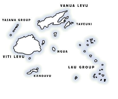
Fiji consists of approximately 300 islands ranging from coral atolls to high-rise subcontinental land masses, about 100 of which are populated. Viti Levu is the main island, with the capital located on the eastern end at Suva which is also the site of the international airport an Nadi (sometimes written Nandi) on the western end.
Vanua Levu is the second largest island, but beyond the urban centers on Viti Levu, it and most other islands in the country are relatively undeveloped. Fiji has a land mass of 18,270 sq. km. It is slightly smaller than New Jersey. Its two main islands are categorized as subcontinental, and have vast tropical forests and even a gold mine, contrasting with other Polynesian islands which typically have few natural resources beyond tropical forests and the sea.
-
Population
Fiji has a population of approximately 884,887, 56.8% of them indigenous Fijian (I taukei) with their Polynesian admixture and 37.5% of Indian descent. The remaining 5.7% is a comprised of Europeans, other Pacific islanders, Chinese and others.
-
History and Discovery
Archeologists know the predecessors of the Fijians first came to these islands over 3,000 years ago, and their ancestors eventually moved on to Tonga and Samoa. Dutch explorer Abel Tasman accidentally discovered Fiji in 1643. British Captain James Cook also sailed through the islands in 1774, but credit for the first significant European exploration usually goes to Captain William Bligh, who sailed past "the Feejees" following the famous mutiny on the Bounty in 1789. He returned several years later in his quest to punish the mutineers. Shipwrecked sailors, sandalwood traders and Christian missionaries followed.
When paramount chief, Ratu Seru Cakobau, converted to Christianity in 1854, intertribal warfare and cannibalism soon ceased. As hereditary Fijian tribal chiefs watched the encroachment of European colonialism among the Pacific islands in the 18th and 19th centuries, they collectively elected to associate with Great Britain in 1874.
The first British Governor-General of Fiji, Sir Arthur Gordon, formalized the Great Council of Chiefs hoping to ensure traditional leaders would maintain control over a large majority of the land in Fiji. Although the council was legally abolished in 2012, the desired outcome of traditional control still basically exists today which is not always the case in some other traditional Polynesian lands.
From 1879 to 1916, the British government imported indentured Indian laborers to work on sugar cane plantations and in other industries. After the indenture system was abolished there 60% of the Indian population chose to remain in Fiji, where their descendants live today as small farmers and business owners. In 1970, the citizens of Fiji elected to become an independent nation.
-
Language
Fijians utilize an ancient Austronesian language that is related to their more modern"cousins" of Tonga and Samoa. Historical linguists often trace a language's roots against such cousins by noting which sounds and features have been kept or dropped, determining that newer languages and dialects tend to have fewer sounds and features. In this simplistic explanation, therefore, linguists have shown that Fijian is far more ancient than Tongan or Samoan, which are likewise even older than Tahitian and Hawaiian.
Today, Fijian (in various dialects) and English are widely spoken, along with various Indian and other Pacific island languages. The sounds represented by several written Fijian letters are different than their English counterparts.
More specifically, the consonant 'b' is pronounced as an 'mb' sound, even at the beginning of a word; and the consonant 'd' is pronounced as an 'nd' sound, also even if it comes at the beginning of a word. Hence, the written word Nadi (where the international airport is located) is pronounced as if it were written 'Nandi' (non-dee).
There are three other differences: 1) The sound represented by the Fijian letter 'g' is an unreleased g-sound, as in the English word "singer," even if it comes at the beginning of a word; 2) the letter 'q' is pronounced in Fijian with a released-g sound, as in the English word "finger," again even if it comes at the first of a word; 3) and the letter 'c' is actually pronounced as an English 'th' as in the word 'that.' Consequently, the name Cakobau, one of Fiji's great traditional chiefs, is sometimes written more like it is pronounced which is "Thakombau."
-
Village Life
Yaqona or Kava
Yaqona or Kava - A common drink used throughout Fiji that was historically prepared for allspecial ceremonies. The yaqona plant is related to the pepper family, and although it's sometimes described as narcotic or intoxicating, it normally only has a slight numbing effect on the tongue when used in moderation. When needed, yaqona roots are dried and pounded into a fine powder which is then mixed with water and served ceremonially.Fijian Clay Pottery
Fijian pottery is derived from Lapita potters who brought the tradition with them to the islands about 3500 years ago. Pottery from clay would be molded and completed by hand, to be set aside for the family's use or exchanged for other needed household objects.
I wau — Fijian Clubs or Chiefly Weapons
As late as a century ago Fijians used many types of war clubs, starting with the gadi, a small ornamental club carried by correctly dressed warriors and chiefs at ceremonial occasions during peace times. All clubs were hand carved from the wide array of tropical hardwoods which grow in abundance in Fiji. In fact, when Brigham Young University Hawai'i recently built a 57-foot traditional twin-hulled Hawaiian sailing canoe, they imported the wood from Fiji.Many of the war clubs also included fine linear carving on the handles, reflecting the personalities of the individual warrior who made and used them. Fijian clubs fall into several categories: Bowai or pole clubs are similar to long baseball bats, but sometimes with wider heads. These were used for breaking bones and general disabling blows. Waka or root clubs had straight handles with a natural knot of roots at the end and were used to crush skulls easily. Cali were spurred or "gun stock" clubs, so-called because they resembled rifles, although Fijians devised these clubs long before they became aware of rifles. They were designed for cutting and disjointing blows. The i ula were throwing clubs with short handles and bulbous heads. These were the deadliest Fijian weapons, capable of competing with revolvers in close situations. If the handle struck the victim first it could penetrate flesh, the heavy head then jack-knifing onto the victim even if the handle did not pierce him, thus dealing a crippling, if not a finishing blow. And the kiakavo, a Y-shaped club, was utilized mainly as a dance implement so it was constructed of lighter wood and was usually not finely decorated.
-
Interesting Facts
Fijians do not wear hats because they believe the head is very sacred. Your understanding and respect for their customs and traditions will make you a welcome guest in their villages and homes.